Sir Creek: History, Dispute, and Strategic Importance
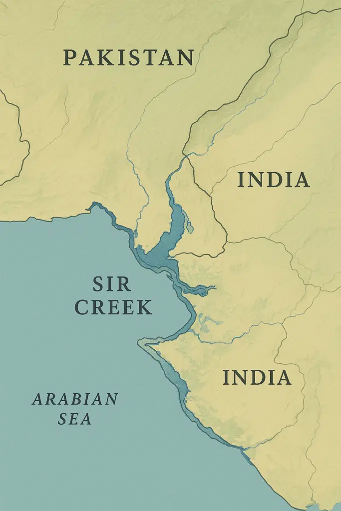
Sir Creek is a 96-kilometer tidal estuary situated in the marshlands of the Indus River Delta, along the border between India’s Gujarat state and Pakistan’s Sindh province. Though it appears to be just a narrow strip of water flowing through an uninhabited marshland, the creek has become a focal point of geopolitical interest due to its strategic location, maritime boundary disputes, and natural resource potential. Over the decades, Sir Creek has stood at the crossroads of territorial disagreements, naval strategies, and resource exploration, making it far more significant than its modest geography suggests.
What is Sir Creek?
-
Sir Creek is essentially a tidal creek that divides the Rann of Kutch region of Gujarat (India) and Sindh (Pakistan).
-
It runs from the Arabian Sea inland and is part of a network of waterways in the Indus Delta.
-
The creek is a marshy estuary that gets submerged during high tide and dries out considerably during low tide.
-
Despite its inhospitable terrain and lack of permanent human settlement, it has emerged as a sensitive and strategically contested boundary zone between India and Pakistan.
Historical Background of the Dispute
The roots of the Sir Creek dispute trace back to colonial times:
-
1890 Bombay Government Resolution
-
The Bombay Presidency (under British India) issued a resolution that considered the eastern bank of Sir Creek as the boundary between Sindh and the princely state of Kutch.
-
-
Differing Interpretations of the 1914 Map
-
A 1914 map signed by the then rulers of Sindh and Kutch placed the boundary along the middle of the creek (the “thalweg” principle).
-
However, later interpretations and administrative records showed contradictions on whether the boundary lay along the eastern bank or the midstream of the creek.
-
-
Post-Independence Scenario
-
After the partition of India in 1947, the dispute became a matter between India and Pakistan.
-
During the Indo-Pak war of 1965, the issue gained more prominence as part of the larger territorial dispute over the Rann of Kutch.
-
While arbitration by an international tribunal in 1968 settled much of the Rann of Kutch boundary, Sir Creek remained unresolved.
-
Strategic and Geographical Importance
1. Maritime Boundary Demarcation
-
The position of the boundary in Sir Creek determines the extent of Exclusive Economic Zones (EEZs) in the Arabian Sea.
-
EEZs are critical for fishing rights, seabed exploration, and potential exploitation of oil and natural gas reserves.
-
A shift of just a few kilometers east or west can give either country hundreds of square kilometers of maritime territory.
2. Fisheries and Livelihoods
-
The Indus Delta and surrounding Arabian Sea waters are rich in marine biodiversity, supporting thousands of fishermen from both India and Pakistan.
-
Disputes in Sir Creek often lead to arrests of fishermen who inadvertently cross into contested waters.
3. Energy and Resource Potential
-
Geological surveys have hinted at the presence of hydrocarbons and natural gas deposits beneath the seabed in the Sir Creek region.
-
Both nations see the area as economically significant, with long-term energy security implications.
4. Military and Security Considerations
-
The proximity of Sir Creek to Karachi (Pakistan’s economic hub and naval headquarters) and Kandla port (India’s major port in Gujarat) enhances its military sensitivity.
-
The marshy terrain is also viewed as a potential infiltration route for militants or smugglers, making it a security hotspot.
-
Both navies routinely patrol the area, adding to its strategic weight.
5. Environmental Significance
-
Sir Creek lies within the fragile Rann of Kutch ecosystem, home to migratory birds, mangroves, and marine species.
-
The region is also prone to cyclones and flooding, which can alter its geography and complicate boundary demarcation.
Key Points of the Sir Creek Issue
-
Boundary Alignment:
-
India claims the mid-channel (thalweg principle) should be the boundary.
-
Pakistan claims the eastern bank should be the boundary.
-
-
Implication of Claims:
-
India’s interpretation gives it a larger maritime area in the Arabian Sea.
-
Pakistan’s interpretation shifts the maritime advantage towards Karachi and Sindh.
-
-
Arrests of Fishermen:
-
Due to lack of a clearly demarcated boundary, fishermen from both sides often cross unknowingly, leading to detentions and diplomatic tensions.
-
-
Confidence-Building Measures:
-
Both countries have attempted joint surveys and discussions, but political and military distrust has prevented a permanent solution.
-
Periodic dialogues (such as the India-Pakistan Joint Working Group on Sir Creek) have been held, but with limited outcomes.
-
Possible Pathways for Resolution
-
Joint Hydrographic Survey
-
Both nations can rely on modern satellite mapping and hydrographic surveys to establish an accurate boundary line.
-
-
Resource Sharing Agreement
-
Instead of a rigid territorial claim, a joint development agreement for fisheries and hydrocarbons could reduce friction.
-
-
International Mediation or Arbitration
-
Similar to the Rann of Kutch dispute, a neutral international tribunal could help resolve Sir Creek through legal arbitration.
-
-
Confidence Building
-
Establishing fishermen’s safety protocols, early release of detainees, and joint patrol mechanisms could reduce humanitarian fallout.
-
Conclusion
At first glance, Sir Creek may look like an uninhabited, marshy wasteland of little consequence. Yet, its location at the crossroads of national boundaries, maritime zones, natural resources, and naval strategy has made it one of the most significant unresolved disputes between India and Pakistan. Whether it becomes a flashpoint of conflict or a platform for cooperation depends on the political will of both nations.
For India and Pakistan, resolving Sir Creek could not only unlock vast economic potential in the Arabian Sea but also serve as a confidence-building measure in an otherwise fraught bilateral relationship.
Frequently Asked Questions (FAQs) about Sir Creek
1. What is Sir Creek?
Sir Creek is a 96-kilometer-long tidal estuary in the Indus River Delta region, lying between India’s Gujarat state and Pakistan’s Sindh province. Despite being marshy and largely uninhabited, it is strategically and economically important due to its link with maritime boundaries, fishing resources, and potential hydrocarbon reserves.
2. Why is Sir Creek disputed?
The dispute arises from different interpretations of colonial-era maps and agreements.
-
India follows the thalweg principle, arguing that the boundary should run along the mid-channel of the creek.
-
Pakistan insists the boundary lies along the eastern bank, which would push the maritime boundary further into the Arabian Sea in its favor.
3. Why is Sir Creek strategically important?
Sir Creek directly impacts the Exclusive Economic Zones (EEZs) of both India and Pakistan. EEZ boundaries determine control over fishing areas, mineral resources, and possible oil and gas reserves. Additionally, the creek’s proximity to major ports and naval bases like Karachi (Pakistan) and Kandla (India) makes it militarily sensitive.
4. What is the history of the Sir Creek dispute?
-
Originated during British colonial rule in the late 19th and early 20th centuries.
-
A 1914 map created confusion about whether the boundary lay at the midstream or the eastern bank.
-
After independence in 1947, India and Pakistan inherited this disagreement.
-
Arbitration in 1968 settled other parts of the Rann of Kutch dispute, but Sir Creek was left unresolved.
5. How does Sir Creek affect fishermen?
The lack of a clearly marked boundary leads to frequent arrests of Indian and Pakistani fishermen who unintentionally cross into contested waters. Both governments face criticism over humanitarian concerns, as many fishermen remain detained for years.
6. Are there natural resources in Sir Creek?
Yes. The seabed in and around Sir Creek is believed to contain oil and natural gas deposits. The area is also rich in fish and marine biodiversity, making it economically valuable for both countries.
7. Has there been any attempt to resolve the Sir Creek dispute?
Yes. Both countries have held multiple rounds of talks and even conducted joint hydrographic surveys. While there have been suggestions of arbitration or joint resource-sharing, no permanent agreement has been reached due to political and security mistrust.
8. What could be the possible solutions?
-
Joint development agreements for fisheries and hydrocarbons.
-
International arbitration, similar to past boundary disputes.
-
Confidence-building measures, such as protocols for safe fishing and faster release of detainees.
-
Using modern satellite mapping and hydrographic data to redraw accurate maritime boundaries.
Final Note
The Sir Creek dispute remains one of the last unresolved boundary issues between India and Pakistan. While it may appear geographically insignificant, its strategic, economic, and security implications make it a matter of high national interest for both sides. A peaceful resolution could unlock new opportunities for cooperation in the Arabian Sea and serve as a stepping stone towards better regional stability.


Leave a Reply